UNITED STATES – WYOMING
Wind River High Route

15 August 2021
The Wind River Range is an area I’ve become familiar with. For a backpacking trip a couple of years ago, we linked up several section to see the highlights in the southeastern part of the range. Since that hike, my friend Clinton and I wanted to try a more ambition route. As we read about more hikes in the range, we eventually settled on the Wind River High Route. The high route is more theoretical than it is established. The idea behind it is to travel the full range and stay high rather than venturing through the valleys. There’s one big caveat to the high route, the majority of it is off-trail.
There are several variations to the route with the most well-known being from Andrew Skurka and Alan Dixon. The Skurka route is far more challenging, going right through the hard areas rather than around them. We choose a mix, mostly following the Skurka path except for planning to finish at the Green River trailhead rather than the remote northern region. The route was going to be tough with multiple passes each day and a strong emphasis on navigation. Overall, the plan was to walk some 100 miles and finish in 8 days. We’d spend the spring getting in shape for the attempt and dialing in our pack weights. In early August, it was finally time to head to Wyoming.
Day 1
We began the day early with breakfast at Burger King before Bobby’s dad, Scott, shuttled from Pinedale to the Big Sandy Trailhead. The trailhead was packed with cars filling up the alternate parking lots. On the trail, it was one large group after another until we reached Big Sandy Lake. From there, most people continued into the Cirque of the Towers but we’d head further south.
Our destination was Deep Lake where we’d set up our tents and drop weight for some peak bagging. We’d continue on with light supplies past East Temple Lake and up to a saddle situated to the southwest of the peak. The climb from there took us off the trail and the grade steepened considerably. As we continued on, we kept a close eye on the skies for any afternoon thundershowers. We made a push up the final sections but the rocks above us obscured our view of the clouds. Although we’d struggled, the land finally leveled out as we neared the top. Across the range, we could see dark clouds in the distance. For the time being, we got lost in the views. East Temple Peak features a vertical relief to the north, with the rock wall falling straight down to Deep Lake far below. While the peak isn’t all that well known, one of its highlights is an unsupported rock protruding out over the cliffs. The location was an outdoor experience one dreams of and we’d gotten caught up in it. The distant rain clouds were suddenly upon us and a light rain began to fall. Its pace picked up quickly and, before we knew it, turned to hail. It was becoming a bad situation, but we found a rock overhang just before the thunder and lightning started.
We were able to wait out the rain but the sun was beginning to fall. Back at the saddle, colors were illuminated the skies to the west. The colors deepened as a sunset only added to what had already been an incredible day. We made it back to camp just before we required our headlamps. We weren’t acclimated and hadn’t been disciplined with our calories. We were now exhausted, tired and hungry and it had us concerned for what was to come.
Day 2
Day two began much better than we’d expected. Despite the tough finish to the day before, we woke with fresh legs and were ready for the day ahead. It was going to be another hard one. We’d start by retracing our way back down to Big Sandy Lake. When we arrived there, the weather was turning. As we continued up towards Jackass Pass, the rain began. This time, it never got too bad but we stopped and waited it out to avoid being caught above tree line. once it stopped, our trek continued. Before long, we’d made it to the top of the pass. The view is the most famous in the range with Pingora jutting out into the Cirque. From there, we had to give up much of the elevation we’d just gained as we made our way to Lonesome Lake. As the rain started again, we decided to use the time to eat an early lunch. We had little time to recover before our next challenge in Texas Pass.
The climb out from Lonesome Lake is a tough one. The elevation gains come quick and it’s hard to keep your footing at times. We passed Darwin onthetrail on the way up and it provided a good boost in our attitudes to help us reach the top. Texas Pass is well travelled but not officially “on-trail”. The backside is very steep and we were concerned that it would be tough to travel since it was wet. To our surprise, it was fairly grippy and we easily made our way down.
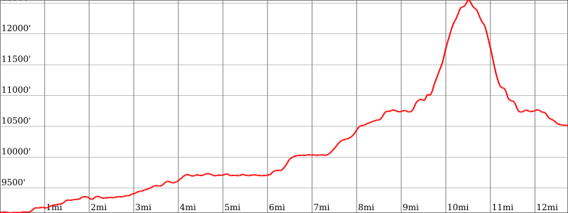
This uncelebrated side of the Cirque is nearly as beautiful as the front. We made our way past several lakes, taking in the views along the way. Eventually, we turned off onto Hailey Pass Trail. Going past the turn off for the pass itself, we continued on until the trail ends at Pyramid Lake. We got just off trail before setting up for camp the second night. It had been a challenging day of 15.75 mile with 4125 ft of elevation gain but we were proud that we’d been able to push through the weather and meet our daily goals.
Day 3
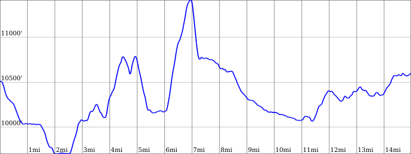
Day three was different. We’d spend the entire day off-trail. It was a short walk from our campsite into the shadows of Raid Peak. Just beyond the peak, we could see our first obstacle for the day: Raid Pass. Unlike the previous passes, the way up this one relied on our abilities. There was no avoiding the boulder hopping all the way up. Ultimately, Bobby picked the most efficient route but we all managed.
The next section was unclear with several different ways to tackle it. We weren’t able to follow the contours as we wanted and had to drop back down into the valley. From there, we were able to find some good ramps alongside a waterfall to climb our way up and to Bonneville Lakes. There seemed to be few ways up the next, unnamed pass but we were able to put something together once we got up to the cliffs.
Dropping off the backside, we’d begun to enter the heart of a range. It was straight down (and more boulder hopping) to the distinctive Pronghorn Peak. We’d have lunch there with our destination for the night visible far in the distance. The way there looked easy and enjoyable passing alongside two large alpine lakes. What we didn’t see were the low-growing willows filling the lake’s banks. The next couple of miles were flat but no less difficult and… slow. Finally, we made it to the north side of Middle Fork Lake. It was time to make the final climb of the day. We were all spent but made our way up with relative ease, ready to put our packs down at the top. We arrived at Bewmark Lake and found a near perfect, backcountry campsite. Resting on some boulders, the path we’d followed for the day was visible. We could see for miles as the sun faded.
Day 4
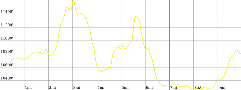
We were upbeat to start day four. Immediately, we’d make our way to the top of Photo Pass. The views lived up to the name but really it felt a bit like more of the same. The Winds are so underrated with an assault of beauty mile after mile. On the other side of the pass, it was a long and brutal half mile slide to the creek below. Following the creek was easy and peaceful but it wasn’t long before he had crossed it and turned up the hillside. We’d continue up for hours more. Walking up the hills was relatively easy aside from the navigation. Back in a forest for the first time in a while, we couldn’t see far in front of us and there were few landmarks. We mostly kept a direct path and the trees began to get shorter and thin out. We’d now reached a section of grass ramps amongst otherwise sharp cliffs. This could have been difficult but Clinton’s planning had paid off and we made it straight up. We were now about as isolated you can get in the range, far from the most visited sections or any trails.
Above 11,500 feet, the landscape was sparse and raw. Nothing but rocks, quiet lakes and hanging glaciers. We ate lunch there preparing for the final push of the long climb. We made it over another pass but it only took us to a saddle between even higher peaks. Straight ahead, Europe Peak stretched further into the sky. There was no clear route to the top and it looked hopelessly impassable. Clouds were rolling in again and we didn’t want a repeat of day one. We tried to be smarter this time and stopped at the only cover we saw anywhere around. We were weighing our options. The weather was less than ideal and we were intimidated by the peak before us. Adventure Alan’s route opted to go around it but add several miles of hiking. We needed to keep on track and voted to try to pick our way up Europe. It was one ledge at a time as we moved on, expecting to become cliffed out at any time. Cautiously and to our surprise, we were now over halfway up. Transitioning from class 3 to class 4 terrain, we reached a knifes edge. The wind was whipping around us but our adrenaline took us to the other side where we were ecstatic about our accomplishment.
There was no cliff on the backside of Europe Peak. We’d now ventured into a high-altitude plateau connecting various peaks with valleys all around and views far into the distance. The mountains in front of us seemed to never move closer but, eventually, we did begin to drop into the valley where we’d make camp. We’d make our way past a small, unnamed lake, again picking our way through the willows. Following the steep banks, we were able to escape them and find our way to the famous Golden Lake. We’d cross its outlet before calling it a day.
Finally, we felt like we were going to be able to finish this. We’d grown stronger each day and had found our stride. Our spirits were high as we discussed what was to come but it’s crazy how quickly things can change… and they did. Clinton was carrying a Garmin Inreach and his father-in-law had messaged. The season’s first snow storm was nearing and he advised us to get to the nearest trailhead. We didn’t know what to do. This was our only source of information and we hadn’t seen anyone for over a day. We weren’t prepared for snow or the lows that came with it. While we didn’t want to end our hike early, we didn’t want to require a rescue the next day either.
Day 5
*I took no pictures for the day so here are some videos of the hike.
It rained all night and solidified our decision that we should get out. As I was still finishing up my breakfast, we made our way up towards Hay Pass. The rain picked up but once we hit the top, we were on a mission to make it back. Finally back on a trial, we were cruising. One lake, two lake, three lake, we kept our eyes on the trail ahead. We skipped lunch to continue on. By early afternoon, we’d put in 22 miles and finally saw the first people in nearly two days. We were a bit crushed that we had to abandon our original plan but, at the same time, there’s nothing like that first meal when you get out.
Thoughts
In the end, we didn’t achieve what we’d hoped but you can’t second-guess your decisions in the mountain. Things can go wrong quickly and we had limited resources to draw on. It was a great experience and one that humbled all of us. The mountains are wild and shouldn’t be underestimated. We’d prepared well but you’re always at their mercy. This time they showed their strength but at least we can remember those five days we traveled in them.
The High Route was a huge challenge and one that requires a lot of preparation. The mileage seems very doable but moving off a trail shouldn’t be underestimated and slows things considerably. If you’ve done several backpacking trips before and are comfortable with being self-reliant, this could be the next step in your outdoor adventures.
Subscribe to our Awesome Newsletter.
