DAY 1 – After the fairly elaborate journey from Lima (read about getting to the trailhead in PART 1), my brother-in-law, Nathan, and I had arrived in the tiny village of Cashapampa at 10 in the morning. We met with the park ranger and each paid the park entrance fee of around $20 USD. Heading up slightly, the trek enters into a valley right away. Here it is rather narrow with a river cutting through the middle. Make sure you have plenty of water on hand as the slope won’t remain gentle for long. This will be the most difficult stretch of the hike you’ll encounter until crossing the pass in a couple of days. Thankfully, the early September weather was mild and mostly cloudy skies shaded us from the sun. With fresh legs and an excitement to be on the trail, we were able to push through without too many breaks. However, it was still a great relief when we glimpsed the first campsite in the distance. By late afternoon, we had completed the 6 1/4 mile trek and arrived at the campsite.

I had mixed feelings about the campsites along the trek. The camping is basic and there are no facilities of any kind. The areas were all well cleared and offered plenty of relatively flat areas to pitch a tent. Unfortunately, there were no designated areas to separate the many organized trekking groups (and their donkeys) from independent backpackers. They were littered with donkey manure as they were allowed to roam freely. This proved to be an issue from the outset.
After a long day, we were ready for dinner. With our tent up, we found a stone wall to crouch behind and block the wind from our stove. It wasn’t long before someone let us know that a donkey had gotten into Nathan’s pack. I ran the donkey off but much of the damage had already been done. Nathan’s entire food supply for breakfast and lunch had been eaten. Now, we had a decision to make. Could we ration what food we had left and finish the hike or would we have to turn back? Luckily, we had some excess food for a separate day hike we had planned to take after the end our the trek. We decided to press on.
DAY 2 – After a much needed good night’s sleep, the altitude was starting to have an effect on Nathan. He awoke not feeling his best as a headache had started. If you are planning your own hike a little more time to acclimate before starting the trek could be helpful. We were just glad we had chosen to hike in the direction we did as the elevation gains were more gradual each day.
We were packed and on the trail by 9 am. Before long, the river widened as we approached a lake. It was a welcome change in scenery and the trail climbed above it offering excellent views. Waterfalls flowed down as well from the snow-covered peaks in the distance. The trail continued along the lake for another half mile or so. Eventually, the lake dried up entirely into a barren, sand-covered plain. The site of a landslide a few years ago, this section of the trail can be difficult to locate. Stay in the base of the valley and continue along the sand at the same gentle uphill grade as you encountered in the morning. At the end of this washed out area, we crossed over the river and took the chance to filter some water. It would be needed as the trail makes a sudden climb upward. Several trails cross here but stay right and go up the hill continuing along the same valley. This portion of the trail is tough, especially at the end of the day, but just after we reached the top of the hill the campsite came into view.

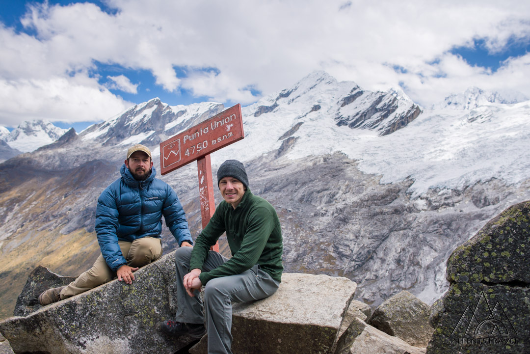
DAY 3 – When we reached this campsite, things begin to change. The altitude increases were more clear now than before and the temperatures were markedly cooler. The overnight temperatures had dropped to around the freezing point and it was difficult to leave the warmth of our sleeping bags. We got off to an early start and, thankfully, Nathan’s altitude sickness had eased. In front of us, the valley where we spent the last two days was sealed off. The climb up to the pass began right away. What started as rolling hills quickly turned to steep switchbacks. With an oxygen percentage nearly half that of sea level, the elevation was making things difficult now. As we got tired, it became increasingly hard to regain our breath. We committed to taking a short break at each turn. The higher we got, the stretches became shorter and shorter. With the final push in sight, Nathan pressed on. I was struggling. Finally, I met him at Punta Union (4,760m/15,617 ft). It felt like every bit of an achievement as I had expected. This had truly been a long journey and we were both relieved that despite the challenges we had accomplished our goal.
Crossing over the top of the pass, we got our first view of the landscape on the other side. The trail plunged down, with the mountains surrounding the small ponds that dotted by valley below. I’m not sure about Nathan but I’d looked forward to the end of the climb up. My relief was short-lived. The grade of this downhill section was no better. Finally reaching the bottom of this dramatic drop, we put down our packs and took an extended break beside a small lagoon. We would spend the rest of the day descending further and further. After the longest and most difficult day yet, we finally reached Paria Valley to camp for the night. The Poptart and a half breakfast and Snickers for lunch weren’t enough for this. We were exhausted. We had our ramen dinner and were in our sleeping bags just after sunset.

DAY 4 – At this point, we just had to make a short hike to reach Vaqueria. Just as before, we followed a river but this time the valley was much more lush. The moss covered trees had an eerie feel as the early morning fog settled in. It only took a few hours before we began to see signs of civilization again. At this point you’ll reach the rangers hut, marking the end of the 31 mile (50 km) trek. Be sure to hang on to your entry ticket as the park ranger will check for it as you reach the outskirts of the remote community. From here, you’ll have to walk through the small village to get a ride out. As you come to a split in the road, turn down the hill to the right and cross the river. We didn’t welcome the hike up the hill but were glad to find a van at the top. Through a broken Spanish/English conversation, we agreed to a ride to Yungay (or so we thought).
The ride out of Vaqueria was an experience in itself. After passing through highlands reminiscent of Iceland’s Westfjords, we topped the pass and came to a truly breathtaking view. I haven’t experienced a road quite like this. At the top, it was difficult to imagine how we would get down. The switchbacks of the road below seemed endless. For nearly an hour we followed them back and forth until we reached the distant lake below. Surprisingly our ride ended there. We were dropped off with no clear indication of how we would get back to Huaraz. After relaxing to eat some lunch, we walked to the road and flagged down a van that offered to take us the rest of the way back. When we arrived, we enjoyed a much deserved chicken dinner and some Inca Kola before another night bus back to Lima.
There is no doubt these types of trips are challenging. It’s definitely going to be a struggle at times. We certainly weren’t thrilled when the donkey ate our food or when we were gasping for air on the uphill climb to the pass. However, the sense of accomplishment you get by fighting through the adversity can’t be discounted. Overcoming the challenges is a memory that will stick with you far longer than a leisurely day sipping a margarita on the beach. The time you spend on your vacation is certainly important but it’s also short-lived. The memories you make are what will last forever.
Subscribe to our Awesome Newsletter.


